Highway 2 and the Toronto-Waterloo Innovation Corridor
Original Kitchener, Ontario August 11, 2023

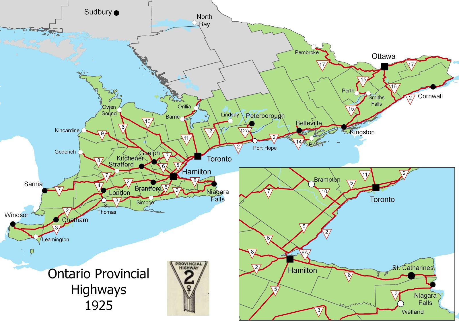
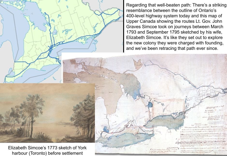
I’ve been fascinated by this map since I first came across it three years ago. Created by Toronto-based geographic analyst, storyteller and advocate Sean Marshall, it shows the Ontario highway system at the dawn of the private automobile era, almost a century ago.
The Department of Public Highways of Ontario was founded in 1916. The Canada Highways Act was passed in 1920 as a post-war economic recovery measure. Every province was to have a plan; the federal government provided 40% of the cost. As part of its plan, Ontario began assigning highway numbers, starting with Highway 2 running west from the Quebec border to Windsor, up to Highway 17, which is now part of the Trans-Canada Highway but at that point only ran from Montreal through Ottawa to Pembroke. By 1925 the numbers were posted on signs and marked on maps. The “King’s Highway” designation with the iconic crown came in 1930.

Highway 2 is Dundas Street in Trenton, my home town in Canada, as it is in many of the towns and cities along the way. I’d always been told that Dundas Street was named after the town of Dundas. But according to the Canadian Encyclopedia, it is the town that was named after the “military road built in 1794-95 from the head of navigation at Cootes Paradise on Lake Ontario to the upper forks of the Thames River,” which Governor Simcoe decided to name in honour of Henry Dundas, the Secretary of State for War and the Colonies.
Colonial settlement usually starts with waterways, but after the initial founding, growth generally takes place by road. What eventually became the King’s Highway 2 is not only the mother of all Ontario roads, it is the progenitor of all ground transportation corridors in the four original colonies that were confederated in 1867: Nova Scotia, New Brunswick, and the two Canadas: Quebec, and Ontario.
What is striking in Sean Marshall’s map of the provincial highway system as it existed in 1925 is how, 129 years after John Graves Simcoe moved on to other imperial assignments, all roads still appear to lead to Dundas-Hamilton. Part of the reason is that the southwestern part of the province, including the Niagara peninsula, had a much more extensively developed road system, stretching out in all directions, compared to the east, which remained, for the most part, a single corridor.
To a large extent, this is still true today. Highway 7, which in the beginning ran only from Sarnia to Guelph, was eventually extended to Ottawa, but it never developed into a second east-west corridor to offset the dominance of Highway 2 and, later, the 401. Sarnia, St. Mary’s, Stratford, Kitchener, Guelph and Brampton were built along this relatively undeveloped, upper-tier corridor, which also connected Peterborough to Ottawa at the other end. The gap, then and now, is the area north of Toronto.
The 401 runs close to Highway 2 in the east, and joins it again in the west from Woodstock through London to Windsor. But it diverges from the original main corridor when it reaches Toronto, veering north and skirting around the Dundas-Hamilton junction by running nearer to Highway 7 settlements like Guelph and Kitchener for a stretch.
The ill-fated Highway 407 project serves as a third east-west corridor for the Greater Toronto Area, but instead of following the Highway 7 route to Peterborough, it veers south to connect to the 401 corridor in the east, and terminates at the original Dundas-Hamilton hub in the west. This follows a pattern set when Highway 402 was built connecting Sarnia to the 401 mainline rather than as the terminus of the old Highway 7 route.
The end result is a system that remains a remarkably dominant single corridor, with only four 400-level connections to points beyond the foundational corridor (416 to Ottawa; 400 to Barrie; 402 to Sarnia, and Ontario’s first Autobahn-inspired, four-lane, limited access highway, the QEW to Niagara).

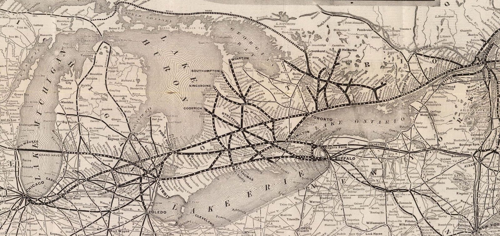
The third dimension of modern colonial settlement, after waterways and roads, is the railroad system. The Grand Trunk Railway ensured the establishment of Berlin, Canada West, as the Waterloo County seat when the line came through here in 1856; the Great Western Railway had connected Hamilton through London to Windsor a few years earlier. So our rail connection was, and remains, what Highway 7 is to Highway 2: a parallel line that has always been secondary to the main corridor, and that is broken up by detours to Toronto.
My impression is that, in western Ontario at least, these mainline roadway corridors were not as dominant over the first century or so of settlement, before the advent of the automobile and the modern trucking industry, as they are today. Highways as they existed in 1925 look like spokes emanating from the Hamilton/Dundas hub, going in all directions to cover all the lands between the lakes west of Brampton, Hamilton and Niagara.
The railway system was also remarkably effective as an all-points connector: On a 1885 map of the Grand Trunk and Great Western railroad network, the system looks like a fully developed grid covering the whole peninsula from Windsor to Niagara to Tobermory, with multiple hubs, most notably Stratford, Palmerston, Brantford and London, but not Toronto, Berlin, Galt or Guelph.
These maps suggest that in the beginning, settlement was centrifugal, going out from centres of power like Dundas-Hamilton and Toronto. But for the last 100 years or so, development has gone in the other direction, with one major centre, one corridor, and one mode of transportation becoming increasingly dominant.
There are some indications that the tide may be turning towards a more balanced approach that seeks equilibrium between the centre and the periphery, and a more diversified transportation system. One of those indicators is the demand for two-way, all-day GO service connecting Toronto with Guelph and Kitchener.

Reflecting on these maps has shaped my thinking about the “Toronto-Waterloo Innovation Corridor” concept, and of the desirability of dominant central corridors in general.
I’m going to start with an off the cuff social media comment I posted recently (it was still a “tweet” at the time). This was in response to news reports about Waterloo’s Opposition MPP Catherine Fife and Kitchener’s Green MP Mike Morrice both calling the Ontario government to task on the lack of progress on meeting the longstanding public demand for two-way, all-day GO trains between Kitchener and Toronto. As Fife put it in an interview with CBC-KW News, for us here in the Waterloo area “the sense of frustration has reached a tipping point." With that map of the Ontario Highway system at an early stage in mind, I suggested that perhaps it’s time to try a different approach:
Maybe we should give up on this two-way, all-day train to and from Union Station pipedream and shoot for a reliable rail connection to Hamilton instead. From there, you can get anywhere.
I’ve long questioned the wisdom of the KW business establishment allowing the “Toronto-Waterloo Innovation Corridor” concept to eclipse the “Canada’s Technology Triangle” brand, which originally included Guelph.
First of all, it’s an unequal yoke: Toronto has assumed the role of Canada’s metropole, and grown to become the fifth or sixth largest urban centre in North America; Waterloo is a constellation of three mid-sized cities surrounded by towns, villages and farmlands. The Greater Toronto Area is about ten times greater than the Waterloo region.
This idea of Kitchener-Waterloo establishing a favoured relationship with Toronto could be taken as an insult to potential allies among cities and regions closer to our size and in comparable situations, like Hamilton, Oshawa, Brampton, Niagara, London, Windsor, Peterborough or Kingston. It looks like KW boosters are trying to shove all such places aside in order to develop an inside track to accessing the undisputed centre of power and wealth.
I also think we’re selling ourselves short: With Guelph, this region is well on the way towards developing into a world-class centre of higher learning, and with that, innovation, and, if we’re serious about making such claims to greatness, a genuine capital of culture as well. Adding Toronto into the mix dilutes this distinction: It’s like England’s unparalleled Oxford-Cambridge culture and learning arc rebranding as the London-Oxbridge Corridor.
The concept is also, as the story told in the maps presented here shows, simply not credible: There has never been anything like a Toronto-Waterloo Corridor. Union Station is a transit hub with lines going out in all directions: Oshawa, Markham, Richmond Hill, Barrie, Pearson Airport, Milton, Hamilton. And every one of these destinations can aspire to developing a reciprocal relationship with the heart of the metropole, and using it to their advantage in establishing credibility as a world-class innovation centre.
The Facebook version of my post went a bit farther, declaring that with regard to commuting by rail
we should face the fact that we are not on the mainline, and never will be. The Quebec to Detroit railroad corridor parallels Ontario's original main road, Highway 2, and runs through Hamilton and Brantford, not Kitchener and Stratford. Up here in Waterloo Country it might be wise to shift our transportation priorities to finishing the LRT -- NOW, not at some vague future date -- and add a firm resolve to connect what will be the spine of a region-wide transit system with an efficient, reliable, 24/7/365 rail connection to both Guelph and Hamilton via Hespeler-Preston-Galt.
I’ll stand by that thought as an impromptu social media comment. On further reflection, I’d tone down the provocation and remove the word “instead.”
A two-way, all-day connection with the Union Station terminus and all the points in between is a reasonable demand for any and all communities served by a GO rail line. It’s also an ambitious one: Two-way, all day is a demand for equilibrium, a refusal to be a mere suburb feeding the city with a one-way stream of talent and energy Monday through Friday mornings, and returning to our respective domiciles at the end of the day.
What is encouraging about the two-way, all-day demand is that it is not just another resentment-based anti-urban stance, railing against the “downtown elite” and their towers of gold, nor is it proposing a disruptive alternative to established ways. The vision is not “instead of” but “in addition to” existing realities. The congestion that plagues the metropole and clogs up the 401 is the result of imbalances in the way power and wealth circulate. Done right, a centrifugal turn away from more than a century of concentration and centralization will benefit both the core and the periphery.
The Toronto-Waterloo concept appears to be evolving into something broader and more inclusive. Sometimes the reference is to “Canada’s Innovation Corridor,” a configuration that is being promoted as “a globally significant economic region centered in the Greater Golden Horseshoe and anchored by Toronto, Kitchener-Waterloo, and Hamilton.”
Behind this concept is a “council” of chambers of commerce / boards of trade with representation from Oshawa, Pickering and Whitby in the east; a couple of lower-tier municipalities in the 905 area; Hamilton, Burlington, Oakville and Mississauga along the Highway 2 lakeshore, and a string of Highway 7 / 401 communities from Brampton through Guelph to Cambridge and Greater Kitchener Waterloo.
The Toronto Region Board of Trade seems to have marked out the same geographic area as its domain: It serves the regional municipalities of Halton, Peel, York, Durham and the City of Toronto, which together form “a key component of the larger Innovation Corridor … ,” an are that, like the KW Tech boosters, the Toronto board claims also includes Hamilton, Guelph and Waterloo Region.
Almost 50% of the GDP of Ontario is generated within this conurbation. But is this really where we live, and what we’re an integral part of? Is this where to draw the line between us, here in the Waterloo or Waterloo-Wellington area, and the world at large?
Canada’s Innovation Corridor is basically the Golden Horseshoe idea from the 1950s, extended to include what I’ve presented here as the Highway 7 / Grand Trunk string of cities to become what is sometimes called the Golden Horseshoe Plus region, but subtracting Niagara and the rest of the QEW string of communities beyond Hamilton.
Golden Horseshoe Plus and Minus shifts the centre of gravity away from Hamilton-Dundas to Toronto (Union Station) and Mississauga (Pearson Airport). Essentially, it’s the 401 corridor from Oshawa, Durham Region, to Kitchener, Waterloo Region that we’re looking at here. Hamilton is connected through the Oakville-Burlington lakeshore (i.e. old Highway 2), but cut off from points east to Niagara and west through Brantford, Paris, Woodstock and beyond.
Preston and Hespeler are near the 401, and historically connected to Kitchener and the rest of what used to be Waterloo Township as part of Block Two of the Haldimand Tract. It is Galt that gets short changed when the Toronto-Waterloo Corridor dominates what we imagine we are, and aspire to be. I’m not sure what the obstacles are that have prevented extending the Milton GO line to its natural limit, but the fact that this objective is rarely even mentioned, here in the region or anywhere else, looks to me a failure of the imagination, and an obtuse refusal to consider all interests and all possibilities.

I’ve been floating the idea of a Grand-Niagara Origins Corridor, not as an alternative but as a complement to all-roads-lead-to-Toronto Tech Corridor. Main Street Kitchener and Preston both lead to Dundas-Hamilton; Main Street Galt runs up to Guelph and down along the river to Brantford and the lands of the Six Nations of Grand River Country. The two routes intersect in the area known as the Delta. When you reach Cambridge city limits in the southeast along the King-Dundas route, the Hamilton city line is within easy walking distance.
Niagara is the original gateway to Waterloo Country: the Six Nations from Upstate New York; the Anabaptists from Pennsylvania; Loyalist refugees from the break-away colonies along the Atlantic seaboard, and the Black pioneers who settled in the Queen’s Bush from what would become the separatist Confederate states all followed this path. The ground on which they settled is the Grand River watershed, including the Haldimand Tract, which predates the colonial county system. These are lands that the founding Governor’s military road traversed, but only to reach points west.
The Grand-Niagara Origins Corridor is best applied as a means towards broadening and enriching the imagination. Any of the original 16 provincial highways could serve a similar purpose for the various communities that formed along them, as could any of the 36 watersheds that constitute Ontario’s network of conservation authorities.

Realizing that from Dundas-Hamilton you can get anywhere opens possibilities. Yes, it’s on the main VIA and GO line to Union Station and all points east. But it is also a gateway to Niagara, Buffalo, Rochester and Cleveland; to London, Windsor, Detroit and Chicago. My complaint with the Toronto-oriented Tech Corridor is that, grand as it sounds, it limits our thinking.
Part of the problem here is a misconception of what a corridor is, and how it functions. It’s the architectural sense of the term that is relevant here: “a long passage in a building, ship, or train, esp. with rooms on one or both sides.” The purpose of a corridor is to connect. It’s an extended junction, not a point of concentration, termination or separation from what’s around it.
We need to start thinking of our mainline corridors as the equivalent of the spine in relation to a body’s nervous system: an integral part of a complex whole. Imagined that way, the various cities along the way -- in our case, Kitchener, Galt, Guelph, Brampton -- are doorways or portals leading to passages to the north, to the south, and to all points of the compass in between. A two-way street only gets you to the end of the line and back. It’s the intersections, and the places they lead to and from, that make a mainline corridor.
This analogy also applies to our local/regional central transit corridor: It is not just a single line running between two 20th-century-style shopping malls, but the spine of a transportation system designed to serve every neighbourhood, every street, every home, every business and every workplace in the region, inside the countryside line, and where feasible, into the Waterloo townships as well. And from every street and every home, the regional transit system also connects us to the main rail corridor, which is the gateway, not just to Union Station and back, but to all points west, south, north and east, throughout Ontario, but also to Quebec, New Brunswick and Nova Scotia, as well as to Michigan, Pennsylvania, Ohio, New York and Vermont.
Whether it’s the Highway 2 / 401 mother of all roads, the GO Lakeshore line, the Quebec to Windsor mainline, or the Grand River Transit LRT route, fixation on “intensification around the central transit corridor” is retrograde, in that it follows the tired mindset of concentration that has shaped development for more than a century. This is what has led us to the impasse we find ourselves at today: gridlock, and nowhere to grow except over precious, irreplaceable farmlands, heritage districts, flood plains and Ontario’s Greenbelt. And it will prove to be self-defeating, in the same way trying to solve traffic flow problems on the 401 by adding more and more and more lanes has been futile.
The opportunity of the hour is to broaden and and enrich prospects in Great Lakes Ontario by going out in all directions, exploring all possibilities and experimenting with an infinity variety of combinations. Sticking to the well-beaten path cramps healthy growth and inhibits innovation.